Join us at our 2nd Annual Blizzard Ball

Forecast for the Logan Area Mountains

Toby Weed
Issued by Toby Weed on
Monday morning, January 20, 2025
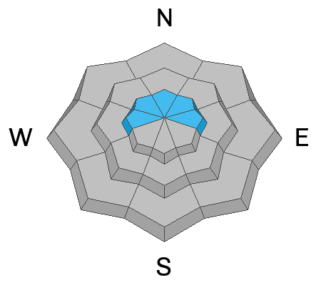
The snow is generally stable in the backcountry, and the avalanche danger is LOW on most slopes. However, areas with heightened avalanche conditions and MODERATE danger exist in drifted upper-elevation terrain where people could trigger small avalanches of wind-drifted snow.
  • Prepare for dangerously cold temperatures and adjust your plans accordingly.
  • Evaluate snow and terrain carefully and practice safe travel protocols by only exposing one person at a time to avalanche risk.
Low
Moderate
Considerable
High
Extreme
Learn how to read the forecast here
Weather and Snow
Be prepared for very cold temperatures again today. It's -11° F at the summit of Logan Peak this morning with a ridiculously cold -36° F wind chill. Plan accordingly and have extra layers, warm drinks, and a fire starter in case of an emergency. Frostbite and hypothermia are a real concern if you stop moving for too long.
This weekend's 4 to 6 inches of new snow is the lightest of the season and made for fun riding conditions. We observed some shallow, loose dry avalanches in very steep terrain and below cliffs involving just the top few inches of the new snow. Winds picked up again early this morning, and with light snow available for transport, the main avalanche problem today is recently drifted snow at upper elevations, where people could trigger small wind slab avalanches. The problem is most pronounced on the lee side major ridgelines and in and around terrain features, where winds deposited stiff drifts. Some drifts built up on preexisting weak surface snow and wind slab avalanches could be 1 to 2 feet thick.
Isolated deep slab avalanches, breaking 2 to 4 feet deep on a persistent weak layer near the ground, are unlikely, yet the consequences could be severe. The likelihood of triggering a persistent deep hard slab avalanche is very low, but we are still suspicious of slopes holding poor snowpack structure, mainly on the north half of the compass. Be cautious of rocky, windswept slopes at upper elevation, and areas with generally shallow snow cover, around 3 feet deep or less, are the most suspect.

-The 8400' Tony Grove Snotel reports -4° F, with an inch of new snow and 59 inches total (96% of normal SWE for the date).
-Winds are blowing from the north-northwest this morning at 9700' CSI weather station on Logan Peak at 17 mph with gusts of 32 mph, and it's -12° F, with a windchill of -36° F.
At our Card Canyon station, it's -8° F at 8800 feet, and there is 46 inches of snow total, with an inch of light new snow.
-On Paris Peak at 9500 feet in Bloomington Canyon, it is -12° F and the winds are blowing from the north-northeast at 15 to 23 mph. The windchill is -35° F.
Today will be another cold day in the mountains, with a forecast high of 7° F and winds from the north blowing 10 to 14 mph. At least it will be mostly sunny. Cold temperatures are the big story for the next couple of days before a gradual warmup toward the end of the week. Snow is possible over the weekend once again, perhaps starting on Friday afternoon.

For more information, visit the UAC weather page here: Weather - Utah Avalanche Center
For Logan-specific weather, go here: Logan Mountain Weather - Utah Avalanche Center
Recent Avalanches
  • There were no recent avalanches reported locally. Read about all avalanches and observations in the Logan Zone HERE.
  • Remember, the information you share about avalanches you see or trigger in the backcountry could save lives.
Ad
Avalanche Problem #1
Wind Drifted Snow
Type
Location
Likelihood
Size
Description
It is possible to trigger small avalanches of wind-drifted snow today. Drifting overnight built shallow wind slabs of new snow in exposed upper-elevation terrain. Some of these could be quite sensitive as they were formed on weak surface snow.
  • Avalanches of wind-drifted snow are most likely on the lee side of major ridges, especially on slopes capped by cornices.
  • Fresh wind slabs may be found in and around terrain features like cliff bands, sub-ridges, gullies, and scoops.
  • Wind-drifted snow is generally stiffer than the surrounding powder, and wind slabs can produce hollow drum-like sounds. Watch for shooting cracks as an obvious sign of instability.
Avalanche Problem #2
Persistent Weak Layer
Type
Location
Likelihood
Size
Description
Dangerous hard slab avalanches failing on a persistent weak layer buried 2 to 4 feet deep are unlikely but remain possible in isolated or outlying terrain with poor snow structure. Weak faceted snow exists near the ground on almost all northerly-facing slopes at upper elevations. While the snow is stable on most slopes, the buried, sugary, persistent weak layer near the ground is still a potential problem in isolated areas. You may not observe any obvious signs of instability before a deep slab avalanche occurs, and the only way to tell if there is poor snow structure is to take out your shovel and dig.
  • Deep slab avalanches are most likely in extreme mountain terrain. Rocky windswept slopes with thin snow cover are the most suspect.
  • Isolated avalanches might be triggered remotely (from a distance) or from below.
Additional Information
Here are two profiles from Shorty's Cutoff in the Steep Hollow area of Franklin Basin from yesterday. The snow is hard and pretty deep. The basal weak layer of faceted snow from November and early December appears to be strengthening. The first profile was done by hand, by digging and examining the layers. The second was produced by the Snow Scope probe produced by Propagation Labs.
General Announcements
-National Forest Winter Recreation Travel Maps show where it's open to ride: UWCNF Logan, Ogden LRD Tony Grove, Franklin Basin CTNF Montpelier
-For all questions on forecasts, education, Know Before You Go, events, online purchases, or fundraising, call 801-365-5522.
-Remember the information you provide could save lives, especially if you see or trigger an avalanche. To report an avalanche or submit an observation from the backcountry, go HERE.
-Receive forecast region-specific text message alerts to receive messages about changing avalanche conditions, watches, and warnings. Sign up and update your preferences HERE.

This forecast is from the U.S.D.A. Forest Service, which is solely responsible for its content. This forecast describes general avalanche conditions, and local variations always occur.