25th Annual Black Diamond Fall Fundraising Party
Thursday, September 13; 6:00-10:00 PM; Black Diamond Parking Lot
25th Annual Black Diamond Fall Fundraising Party
Thursday, September 13; 6:00-10:00 PM; Black Diamond Parking Lot
| Advisory: Moab Area Mountains | Issued by Eric Trenbeath for Sunday - December 25, 2016 - 6:38am |
|---|


|
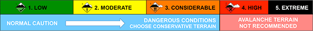
bottom line The avalanche danger is CONSIDERABLE today on steep, upper elevation terrain where blustery winds and blowing snow have created newly deposited wind slabs. The danger is also CONSIDERABLE on upper elevation slopes that face NW-N-SE where human triggered persistent slab avalanches are likely. For MODERATE danger, stick to lower and mid elevation sheltered terrain.
|
 |
special announcement Mountain roads have not been plowed this weekend and access is tricky. Many cars have made it up to the Geyser Pass Trailhead over the past few days, but the road is snow covered and icy and 4wd is required. |
 |
current conditions It's tough to say exactly how much snow has fallen and where. Gold Basin quit reporting at 2:00 a.m. with 9". Geyser Pass Trailhead is reporting only 2" creating a fairly wide discrepancy over 400' in elevation. One thing is for certain, winds hammered yesterday, blowing 20-40 mph first from the WNW then moving around the north side of the compass to the NE. The good news is they tapered off when the snow started to fall. The bad news is they are expected to ramp up again. They are currently light from the SE and it's a chilly 4 degrees on Pre Laurel Peak and 15 at the Geyser Pass Trailhead. Reed Kennard was out and about yesterday and gave us this fine report of the blustery conditions. For a full list of recent observations go here. Storm totals and temperature in Gold Basin.(10,000') Wind, temperature and humidity on Pre Laurel Peak.(11,700') Snow totals, temperature and snow/water equivalent at the Geyser Pass Trailhead.(9600') Things took a beating above tree line this week with southwesterly slopes like these near Pre-Laurel Peak getting scoured down to the rocks. |
 |
recent activity |
| type | aspect/elevation | characteristics |
|---|

|

|
LIKELIHOOD
 LIKELY
UNLIKELY
SIZE
 LARGE
SMALL
TREND
 INCREASING DANGER
SAME
DECREASING DANGER
|
|
description
Strong, gusty winds, and plenty of loose snow available for transport translate to drifting snow and the formation of new wind slabs. Avoid areas of recently deposited, wind drifted snow and look for tell tale signs of instability such as cracking in the snow surface. A triggered wind slab also has the potential to step down into a deeper persistent slab. |
| type | aspect/elevation | characteristics |
|---|

|

|
LIKELIHOOD
LIKELY
UNLIKELY
SIZE
 LARGE
SMALL
TREND
 INCREASING DANGER
SAME
DECREASING DANGER
|
|
description
The snow pack structure is complex and poor in many areas, and snow pits dug on Friday showed that even southerly aspects are not immune. Collapsing and whumphing of the snow pack also continue to communicate instability. Newly deposited wind slabs have added additional stress and increased the likelihood for triggering a deep, persistent slab avalanche. You are most likely to encounter this problem on steep, upper elevation slopes that face NW-NE-SE, but mid elevation slopes are not immune. Best bet is to keep your slope angle to around 30 degrees or less in these areas, and avoid slopes that appear to be drifted. |
 |
weather Christmas Day Snow likely, mainly before noon. Cloudy, with a high near 19. Windy, with a south wind 10 to 20 mph becoming west 20 to 30 mph in the morning. Winds could gust as high as 50 mph. Chance of precipitation is 70%. Total daytime snow accumulation of 3 to 7 inches possible. Tonight A 40 percent chance of snow. Mostly cloudy, with a low around 6. West southwest wind 10 to 15 mph, with gusts as high as 25 mph. Monday Sunny, with a high near 19. Southwest wind 5 to 10 mph. Monday Night Mostly clear, with a low around 10. South southwest wind 5 to 10 mph. Tuesday Sunny, with a high near 24. South southwest wind 10 to 15 mph. |